Items
In item set
Portsmouth Island Items
-
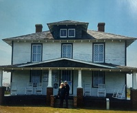 Portsmouth Visitor Center Picture of Barbara Gaskins-Eugene and her son in front of the Portsmouth Island Visitor Center.
 -
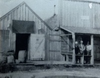 Portsmouth Store Photograph
 -
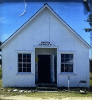 Portsmouth Post Office Photograph of the Portsmouth Post Office
 -
Oral History Interview with Barbara Gaskins-Eugene 2026 Barbara Gaskins, a member of the Friends of Portsmouth Island, shared her family's history and experiences on Portsmouth Island. She recounted her childhood visits, including travel by mail boat and plane, and described the island's historical significance, including its founding in 1753 and the decline in population due to hurricanes. Barbara highlighted her volunteer work with the Park Service, preserving historical buildings, and her efforts to document and share the island's history. She emphasized the island's self-sufficient community, the importance of preserving its heritage, and her plans to write a book about Portsmouth Island.
-
Oral History Interview with Connie Mason 2026 Connie Mason, president of the Friends of Portsmouth Island, shared her journey from East Carolina University to becoming a park ranger at Cape Lookout National Seashore in 1980. She detailed her role in creating interpretive programs and organizing oral histories. Mason highlighted the Friends of Portsmouth Island's efforts, including raising $50,000 for park projects and maintaining historical sites. She discussed the challenges posed by climate change, such as king tides flooding more of the island every year. Mason emphasized the importance of community support and the historical significance of Portsmouth Island as one of the first and one of the largest settlements on the Outer Banks.
-
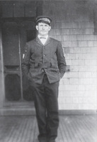 Unidentified Lifesaving Crewman This was a member of the Portsmouth lifesaving station crew around 1915. Based on his hat, he appears to have been a part of the US Lifesaving Service, not the Coast Guard.
 -
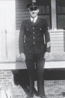 Unidentified Coast Guard Officer This is a member of the Portsmouth lifesaving station crew about 1915, likely a US Coast Guard Officer. A photographer came through and took many photographs of Portsmouth Island around this time, many of which have not been idnetified
 -
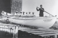 Surf Boat Drill Portsmouth This is a surf boat drill at the lifesaving station around 1910. Lifeboats like this would be sent out through the surf to rescue the people aboard ships in distress in the ocean or sound.
 -
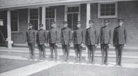 Lifesaving/Coast Guard Crew (1915) This was the lifesaving crew about 1915. The crew was under the supervision of Capt. Charlie McWilliams, who is probably the man at the center. It is not known if this was the Lifesaving Service crew or the Coast Guard crew.
 -
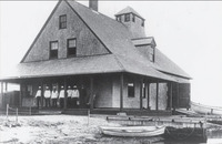 US Lifesaving Service Station In 1894, the new US Lifesaving Service station at Portsmouth was finished and opened for operation. There were a number of different station masters. Some were strict, and others were lax. There were many shipwrecks off the coast of Portsmouth, with the lifesaving crew rescuing them with courage and honor. In 1915, the United States created the Coast Guard and made the lifesaving service part of it. The Coast Guard was active on Portsmouth until 1933, when it closed the doors to the station. The building was reoccupied during World War II to observe German U-Boats off the coast. After the war, the Coast Guard station was again decommissioned.
 -
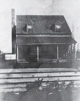 Wallace - Grace - Styron House This house was built about 1850 by Robert Wallace and was later owned by Charles Wallace. It was then purchased by John Grace and Theresa Burgess Grace. The Wallaces were lighterers as well as pilots, operating in the channel. By the early 1900s, the house was owned by Walker Styron, who was a member of the Coast Guard station on the island. The house was used by several families during the hurricanes of 1933 as a storm house. Following the hurricane of 1944, the Styrons left the island for Oriental, North Carolina.
 -
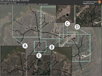 Portsmouth Village Site Plans (2018) A collection of site plan maps of Portsmouth Village
 -
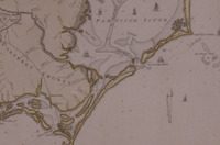
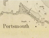 Sketch of Ocracoke Inlet, North Carolina (1852) “Sketch of Ocracoke Inlet, North Carolina,” U.S. Coast Survey, 1852, showing symbols for two churches at Portsmouth, and the word Steeple.
 -
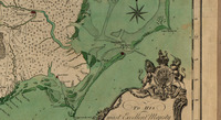
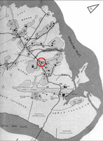 Map of Portsmouth Village (2015) Map of Portsmouth Village showing the location of the Portsmouth Methodist Church. (CALO base map)
 -
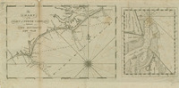 A chart of the coast of North Carolina between Cape Hatteras & Cape Fear (1809) One inset map: "Ocracock Bar including Shell Castle." Depths shown by soundings and stippling. Includes some comments on the sea floor and inlets. The inset map includes inland illustrations.
 -
 A Compleat Map of North-Carolina from an Actual Survey (1770) Shows rural householders' names. Library of Congress Maps of North America, 1750-1789, no. 1500. Relief shown by hachures. Depths shown by soundings. "Publish'd according to Act of Parliament, May the 1st, 1770, by S. Hooper, No. 25 Ludgate Hill, London." "To His most Excellent Majesty George the IIId ... this map is most humbly dedicated by ... John Collet." Includes royal coat of arms. Vault. Library of Congress has 2 copies. Coloration differs. Negative photocopy of copy 1 filed with maps.
 -
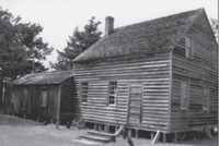 Storm House This is the oldest house left on Portsmouth Island (2021) and was possibly built as early as 1790. It was often called the "storm house" because it had braces to hold it in place during storms. It had a large upstairs where people could retreat from flooding during a major storm. The house was in the Roberts family until it was obtained by David Ireland around 1859. The son of Earles Ireland and Matilda Roberts, he was a blockade runner during the Civil War. When federal troops invaded the island in 1861, most of the people left. The federal officer in command did not burn the house because David Ireland and his father were Freemasons, as was the officer. By the end of the 1800s, Wash Roberts owned the property and lived there along with his sister Jonesie. Wash was a member of the lifesaving crew and a Freemason as well.
 -
 Fort Granville Gabion Remains During the French and Indian War, the North Carolina General Assembly authorized the building of a fort, Fort Granville, on the northern end of the island facing Ocracoke Inlet. This was to replace the old wooden lighthouse that burned on Shell Castle. Gabions, large barrels filled with sand, were placed in front of artillery for protection from enemy fire. Today, the remains of some of these gabions can still be seen when the tide is low and the wind is blowing out of the south, away from the island. There are approximately 10 left (as of 2021) in the water, just a few feet off the island.
 -
 Mouzon Map (1775) a-b. Mouzon Map (1775) An accurate map of North and South Carolina, with their Indian frontiers, . . . by Henry Mouson (sic) and others. Printed. Map Collection
 -
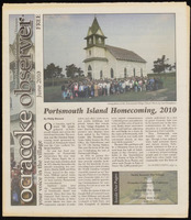 Portsmouth Island Homecoming, 2010 An article in the Ocracoke Observer talking about the Portsmouth Homecoming of 2010. Starts on Page 1.
 -
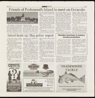 Friends of Portsmouth Island to meet on Ocracoke An article in the Ocracoke Observer newspaper talking about the spring meeting of the Friends of Portsmouth Island being held on Ocracoke in May 2015. Starts on Page 9.
 -
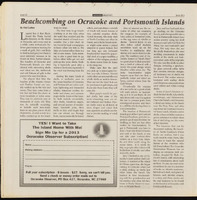 Beachcombing on Ocracoke and Portsmouth Islands An article in the Ocracoke Observer newspaper talking about the hobby of beachcombing on Ocracoke and Portsmouth Islands. Starts on Page 22.
 -
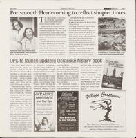 Portsmouth Homecoming to reflect simpler times An article in the Ocracoke Observer newspaper talking about the Portsmouth Homecoming of 2018. Starts on Page 7.
 -
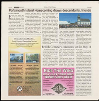 Portsmouth Island Homecoming draws descendants, friends An article in the Ocracoke Observer newspaper talking about the Portsmouth Homecoming of 2018. Starts on Page 12.
 -
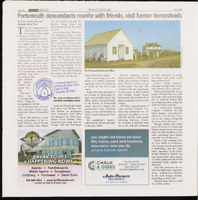 Portsmouth descendants reunite with friends, visit former homesteads An article in the Ocracoke Observer newspaper talking about the Portsmouth Homecoming of 2022. Starts on Page 14