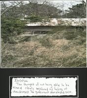
-
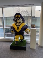 Photograph of the PeeDee Statue in Joyner Library
 Photograph of the PeeDee statue in Joyner Library, donated by Ralph Finch of Beta Phi
-
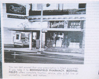 Photograph of Beddingfield Pharmacy
 Black and white photograph of Beddingfield Pharmacy with business advertisement
-
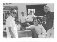 Photograph of Beta Phi Brothers on a Pledge Trip
 Photograph of Beta Phi brothers from the 'Pledge Trip' album.
-
 40 years after trip to Little League World Series
 This is an online article about the 1974 Little League World Series. The team, coached by Curtis Hayes and Henry Davis, led the Pop Smith Little League All-Stars to victory.
-
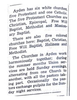 Ayden's Churches
 This is an article that lists the Black and white churches in Ayden, North Carolina.
-
 Sports Briefs: Karate
 News clipping about Demetrius "Oaktree" Edwards defending his heavyweight title.
-
 PKA World Heavyweight Champ To Fight In Durham Wednesday
 News clipping about the Professional Full-Contact Karate sport debuting in Durham, North Carolina. The news clipping discusses Oaktree and his opponent for their upcoming fight.
-
 N.C. Native To Appear On Sportsworld In Karate Heavyweight Championship
 News clipping about Demetrius "Oaktree" Edwards. This clipping highlights his education and how he came to participate in the Professional Karate Association.
-
 Photovoice submission
 Student work created for SOWK 3402: Applied Research and Statistics
-
 Photovoice submission
 Student work created for SOWK 3402: Applied Research and Statistics
-
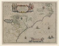
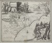 Virginiae Partis Australis, et Floridae Partis Orientalis
-
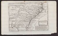 Carolina
-
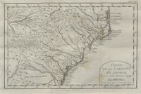 Carte de la Caroline et Georgie pour Servir a L'hist. Générale des Voyages / Tirée des Auteurs Anglois par M.B., Ing. de la Marine
 Amsteldam : , 1773. 1 map : col. Scale [ca. 1,3,800,000]. Relief shown pictorially. Second state, included in Histoire générale des voyages (Amsterdam : Chez E. van Harrevelt & D.J. Changuion, 1774), Tome 21. Copied from the Bellin 1757 map. Cf. Cumming. Southeast in early maps, 444.; At head: "Tom. XXI.". Map framed.
-
 Johnson's North and South Carolina Map
 A map of North and South Carolina by Johnson and Ward.
-
 Zee en Land Togten der Franszen Gedaan na, en in't Americaans Gewest van Florida
 Zee en Land - Togten der Franszen Gedaan na, en in't Americaans Gewest van Florida, aller-eerst door Ioh. Pontius Ontdekt : voyages par Mer et par Terre des François dans la Floride, prémierement découverte par Jean Pontius / dressez sur les Mémoires, et perfectionez par un grand nombre d'autres plus recens, de nouveau mis au jour par Pierre vander Aa, á Leide, Avec Privilege. 1 map : color ; 15 x 22 cm. [Leyden : Pieter Vander Aa, 1714?]. Estimated date from Cumming, The Southeast in early maps. Relief is shown pictorially. Title in cartouche at lower right, surrounded by scenes of sailing ships, explorers arriving on shore, and explorers fighting Indians. Includes ornamental border. In lower right corner, under map: 107. From Aa, Pieter van der. Atlas nouveau. Leide, [1714], II, no. 31. Cf. Cumming.
-
 Americae pars, nunc Virginia dicta
 Map taken from latin translation of Thomas Harriot's A brief and true report of the new found land of Virginia (Frankfurt : Johann Wechel, 1590). 34 pages, 84 unnumbered pages : 28 color illustrations, map ; 35 cm. Copperplate engravings by Theodor de Bry after watercolors by John White.
-
 Virginiae Partis Australis, et Floridae Partis Orientalis, Interjacentiumq[ue] Regionum Nova Descriptio
 1 map : hand col. ; 38 x 49 cm. Scale [ca. 1:2,300,000] (W 86º--W 75º/N 38º--N 30º). Relief shown pictorially. Covers Atlantic Coast from Virginia to Florida. Prime meridian: [Ferro]. Bar scale above the neat line on the lower margin: Milliaria Germanica communia. Includes decorative cartouche and coat of arms. Descriptive text in Latin on verso. From J. Blaeu's Atlas Maior, 1662. Cf. Burden, P.D. Mapping of North America.