
Early Maps of North Carolina:
A Selection from East Carolina University's Special Collections
Maps tell the story of place. They interpret geographies into organized lines and spaces. They also go beyond that and can be used to influence or perpetuate different ideas. These early maps of North Carolina from the Special Collections at East Carolina University relate many stories, starting with John White’s map from his pre-colonial expeditions with Sir Walter Raleigh.
White's Americae Pars was published in A Briefe and True Report of the New Found Land of Virginia. It was included in the book to help promote investment and settlement in the colony. This area was called Virginia after the “Virgin Queen” and is identified as so on many of the maps in the exhibition. King Charles I eventually made the area a royal colony and his son, Charles II, chartered part of it into the Province of Carolina in 1663. The province was given to eight lords proprietors for their loyal service to the King. In 1710, they portioned the Province into North and South Carolina.
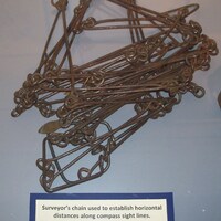
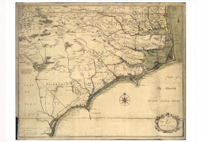
Early mapping relied on complex trigonometry, compasses, sextants, and other surveying tools like the Gunter’s chain. As tools and methods became more sophisticated, so did the maps. Edward Moseley’s A New and Correct Map of the Province of North Carolina, published in 1733, was the most accurate map of the area done up to that point. Moseley used a compilation of previously published maps and his own surveys to draw it. The few Native American tribes depicted on the map tell the story of their diminished populations in North Carolina at this point in history. East Carolina University holds one of the few extant copies of the map. There is only one other in North America and the other two copies are in England.
Illustrations added to maps often transformed them into pieces of art. Several maps in the exhibit have illustrations of trees, sea life and other animals, and ships. It was common to see these included on maps. More often than naught, they were there to serve as decorations but could also depict something about the area. In Willem Blaeu’s Virginae, he included trees and mountains on his map to show terrain and uninhabited places, while at the same time disguising areas that were lesser known.
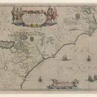
Blaeu depicts Native American figures in brightly colored garb framing the cartouche.Blaeu did not base his work on any specific North American tribe and included them for ornamentation. He emulates the Native American stereotypes that Theodore de Bry perpetuated in his engravings in A Briefe and True Report of the New Found Land of Virginia. De Bry based his work on John White’s watercolors, but he modified the features of the native peoples to fit a more European aesthetic. The skin was made whiter, and the facial features were anglicized. He emphasized their muscularity and portrayed them in the classical style. This representation of Native Americans was copied not only by Blaeu, but other map makers as well.
References: